
 United States
 United Kingdom
 Canada
 Australia
 New Zealand
 Ireland
New Zealand's next low brings thunderstorms before spring westerlies return
WeatherWatchTV's Philip Duncan forecasts another unsettled spell, with northern downpours and substantial rain along parts of the West Coast.
 WeatherWatchTV
Story of
Why this story? One of the most watched videos since yesterday, with 32,877 views.
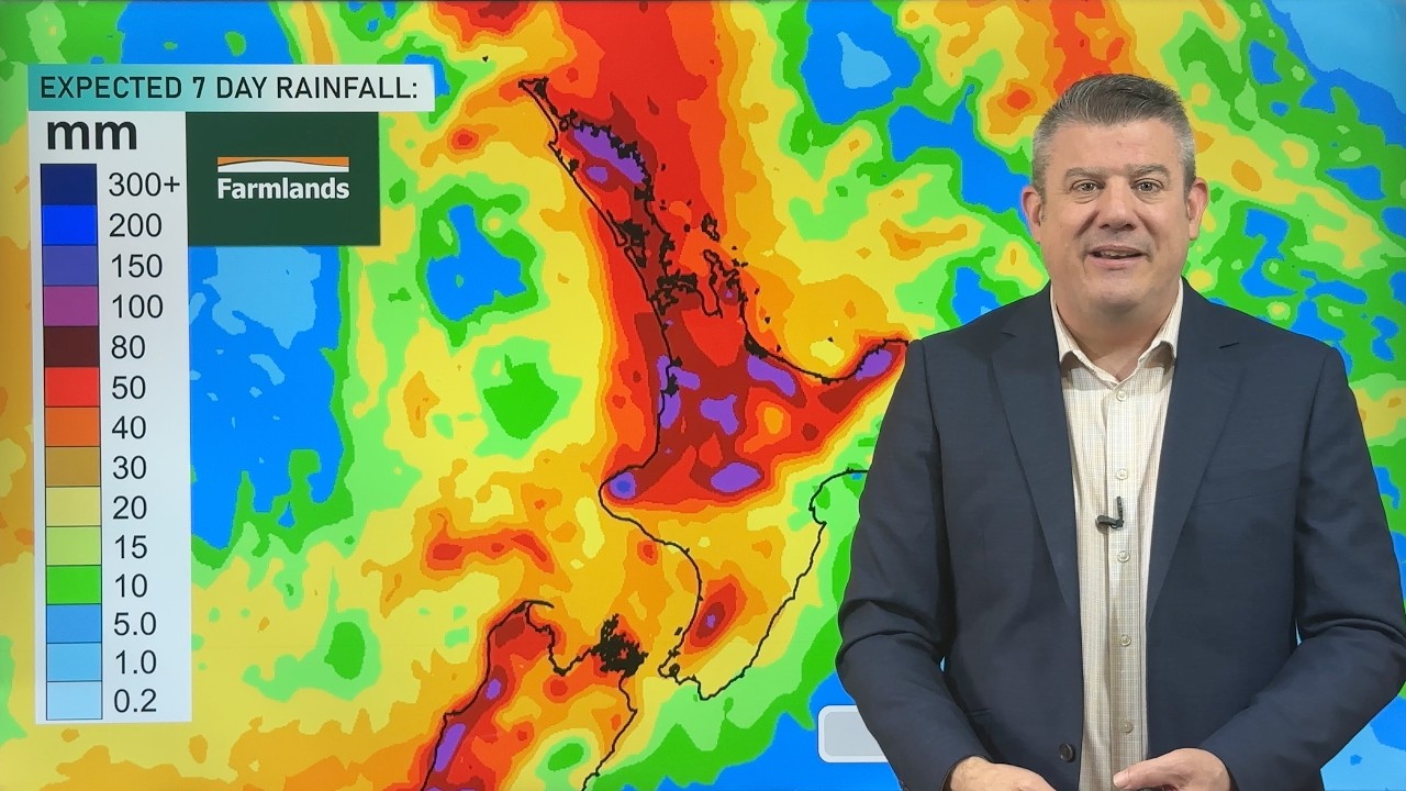 NZ: Thunderstorms & Downpours coming back again
Things we can learn from the video
Press to jump
- 0:09Another Tasman Sea low is driving rain and thunderstorm risks towards New Zealand.
- 1:34Monday's outlook includes downpour risks and cooler winds reaching Canterbury.
- 3:17Tuesday through Thursday bring shifting westerlies and afternoon downpours.
- 5:11High pressure approaches, but Saturday convergence zones and Sunday's subtropical flow leave an unsettled weekend outlook.
- 7:42Seven-day rainfall maps show more than 200 millimetres possible along parts of the West Coast.
Another Tasman Sea low is following close behind the weekend's wet weather, and Philip Duncan's forecast offers no neat switch from rain to sunshine. Downpours, dry spells and thunderstorms are all in the mix, particularly across the upper North Island.
WeatherWatchTV's "NZ: Thunderstorms & Downpours coming back again" drew roughly 33,000 views since yesterday. Its useful distinction is what follows the incoming rain: the low is expected to break apart, but that doesn't mean the showers simply stop.
"It's a change to westerlies, back to the spring westerlies again," Duncan explains. His Tuesday-to-Thursday charts show shifting winds and afternoon downpours, with more isolated thunderstorms possible elsewhere around the country. Cooler winds also feature in the Canterbury outlook.
High pressure moves in towards Friday and the weekend, though Duncan still identifies places where winds meet over the North Island on Saturday, helping showers develop. By Sunday, he describes a returning subtropical flow, while rain returns to the West Coast over the weekend.
The final rainfall maps put that uneven outlook into perspective: parts of the West Coast could receive more than 200 millimetres over the seven-day forecast period. That map segment is supported by Farmlands.
In the comments, the rain has practical meaning beyond the forecast colours. Viewers discuss filling water tanks, newly planted vegetables and fast-growing grass. One also asks for more hour-by-hour map animations rather than a single afternoon snapshot, a useful distinction when the weather keeps changing within the day.
Published on Trari
Where next?



 Is this your channel?For the channel's owners and team: a ready picture and text for your audience
Share the story with your audience. Everything is ready:
For an Instagram story or a WhatsApp status
For a community post or your channel's description
- Channel
- WeatherWatchTV
- Subscribers
- 146,000
- Channel views, last 7 days
- 549,284
- Channel views, pace per day
- 102,190 (on a normal day: 67,357)
- Video published
- November 9, 2026
- Video views so far
- 44,698 (less than a day online)
- Video views, pace per day
- 32,872
The numbers
The forecast added tens of thousands of views since yesterday. Its first-day comment activity was slightly below the channel's usual level.

💡 Test your knowledge
Which sea contains the low-pressure system approaching New Zealand in this forecast?
Duncan places the incoming low over the Tasman Sea, west of New Zealand.