
 United States
 United Kingdom
 Canada
 Australia
 New Zealand
 Ireland
Severe storms forecast across Australia before a wintry southern change
WeatherWatchTV's Philip Duncan maps an eastward-moving storm risk, followed by possible gales, dangerous seas and high-country snow.
 Oz: Severe Thunderstorm Outbreak on the way
Up next

 WeatherWatchTV
Story of
Why this story? One of the most watched videos since yesterday, with 46,250 views.
Things we can learn from the video
Press to jump
- 1:06Low pressure over Western Australia and high pressure to the south shape the opening weather picture.
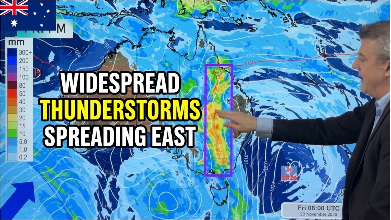
- 2:23The thunderstorm outlook traces severe weather risks eastwards, including damaging hail, flash flooding and wind damage.
- 5:25Friday's forecast highlights a severe thunderstorm corridor with potentially heavy localised rainfall.
- 7:25Monday's early outlook brings possible severe gales, heavy rain, large seas and high-elevation snow to Tasmania and Victoria.
- 8:20The seven-day rainfall map shows how unevenly the expected downpours could be distributed.
Warm weather on Australia's east coast may come with an abrupt change of plans. Philip Duncan's WeatherWatchTV forecast follows severe thunderstorm risks moving across the continent, before a colder system brings a different set of hazards to the south.
The outlook has drawn roughly 46,000 views since yesterday. Its central distinction is useful: a severe thunderstorm is not simply a noisier version of an ordinary one. Duncan explains that damaging hail, flash flooding and localised wind damage are among the risks that make these storms worth singling out, even when they are isolated.
His maps trace storm bands towards South Australia and the Northern Territory, then highlight a severe thunderstorm corridor for Friday, with potentially heavy localised rainfall. Eastern areas get warmer northerly winds ahead of the change.
The forecast then turns sharply cooler. Duncan shows a cold boundary returning to south-western Western Australia over the weekend, with Tasmania and Victoria potentially facing the stronger effects on Monday: severe gales, heavy rain, large seas and a possible dusting of snow at higher elevations. He presents that Monday setup as an early forecast, not a settled outcome.
There is a small audience contribution amid the serious weather. Duncan adopts a viewer's suggested name, "the Thunderbox", for the highlighted storm-risk area. The broadcast closes with a continent-wide rainfall map, showing where the downpours may add up and which places could miss out.
Published on Trari
Where next?
What do you think?
Want to know when somebody answers you?
 For the channel's owners and team
Share the story with your audience
A ready picture for an Instagram story or a WhatsApp status.
Ready text for a community post
- Channel
- WeatherWatchTV
- Subscribers
- 146,000
- Channel views, last 7 days
- 562,106
- Channel views, pace per day
- 187,491 (on a normal day: 69,227)
- Video published
- November 17, 2026
- Video views so far
- 59,161 (less than a day online)
- Video views, pace per day
- 46,215
The numbers
The Australian storm outlook added roughly 46,000 views since yesterday.

💡 Test your knowledge
Which city is the capital of Tasmania?
Hobart, on Tasmania's south-eastern coast, is the state's capital.